Ensuring uncompromising flight safety remains a paramount objective in the unmanned aerial systems industry. To address this critical requirement, the latest software updates introduce highly advanced functionalities for dynamic three-dimensional volume containment. The latest enhanced geocaging features integrated into Veronte OPS offer operators unprecedented authority over operational boundaries. By deploying precise virtual perimeters, these sophisticated tools guarantee that aircraft operate strictly within designated safe zones, automatically triggering predefined autopilot maneuvers or alerting operators immediately.
Geocaging with 3D Volume Containment System
UAS geocaging represents a critical safety net for modern flight operations. It operates as a sophisticated three-dimensional volume containment system designed to restrict an aircraft within airspace specifically defined for an individual mission. When an unmanned aerial vehicle approaches the limits of this predefined airspace, the system engages a mechanism of virtual barriers.
The operator can configure each specific barrier to trigger a series of automatic events executed directly by Veronte Autopilots. Alternatively, the software can be programmed to send immediate, critical alerts directly to the control station. This multi-layered approach ensures the aircraft never inadvertently breaches its designated operational airspace, maintaining strict compliance with aviation authority regulations.
Geocaging Setup in Veronte OPS
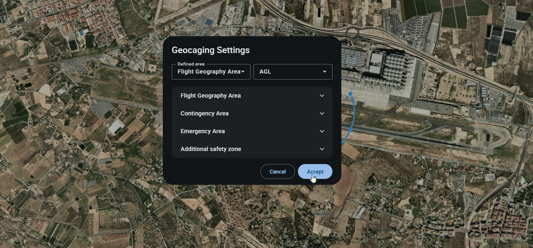
Establishing these secure boundaries is remarkably straightforward within the advanced control station software. In Veronte Ops, you can utilize the dedicated “Create geocaging area” function to manually map out the necessary operational limits around a specific location. This intuitive interface allows operators to establish secure flight zones before deployment, ensuring that all structural safety parameters and barrier events are rigorously defined and active before the UAV ever leaves the ground.
The Power of Geocaging on Route
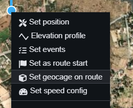
For dynamic missions spanning vast distances, the developed “Geocaging on route” functionality offers a significantly more efficient and automated workflow. Instead of demanding the manual drawing of a massive static area, the system analyzes the planned flight path and dynamically generates a containment corridor directly alongside it. The software seamlessly follows the route sequentially, guided by the directional arrows connecting each waypoint.
Generating this specialized safety corridor requires only a streamlined, four-step technical process:
1. A right-click is executed on a waypoint, ideally selecting the initial starting point of the planned flight route.
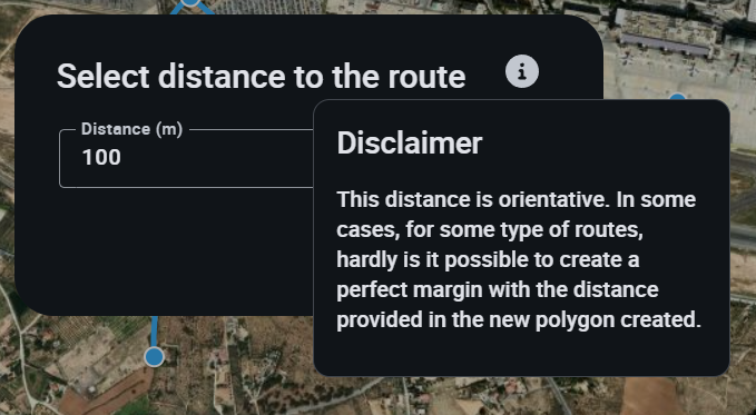
2. The desired lateral containment distance is entered into the resulting dialogue interface.
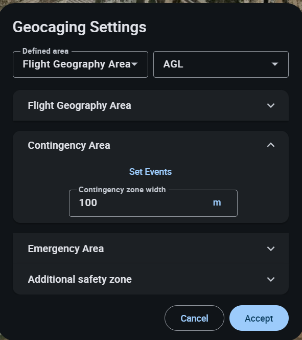
3. Specific adjustments for individual barrier distances and the corresponding geocaging trigger events are finely tuned to match the mission risk profile.
4. Upon acceptance, the precise containment area is generated automatically around the entire flight path.
Crucially, this advanced automation algorithm has been upgraded to be fully compatible with highly complex flight plans featuring intricate curves and sophisticated maneuvers. This ensures that even the most demanding and irregular flight profiles remain entirely protected within the generated 3D volume.
As the aerospace sector demands increasingly autonomous and secure platforms, the continuous evolution of flight control software underscores a deep commitment to operational excellence. By seamlessly integrating these intuitive and robust geocaging capabilities into Veronte OPS, Embention ensures that UAV manufacturers and engineering teams possess industry-leading containment tools. Paired with the unmatched reliability of the Veronte Autopilot, these advanced boundary management systems guarantee that every critical mission adheres to the highest global standards of safety, precision, and technological innovation.
Discover how SORA 2.5 transforms UAS operations with quantitative risk assessment, updated mitigations, and stricter AESA compliance requirements.
Subscribe
Receive news & updates
Latest News
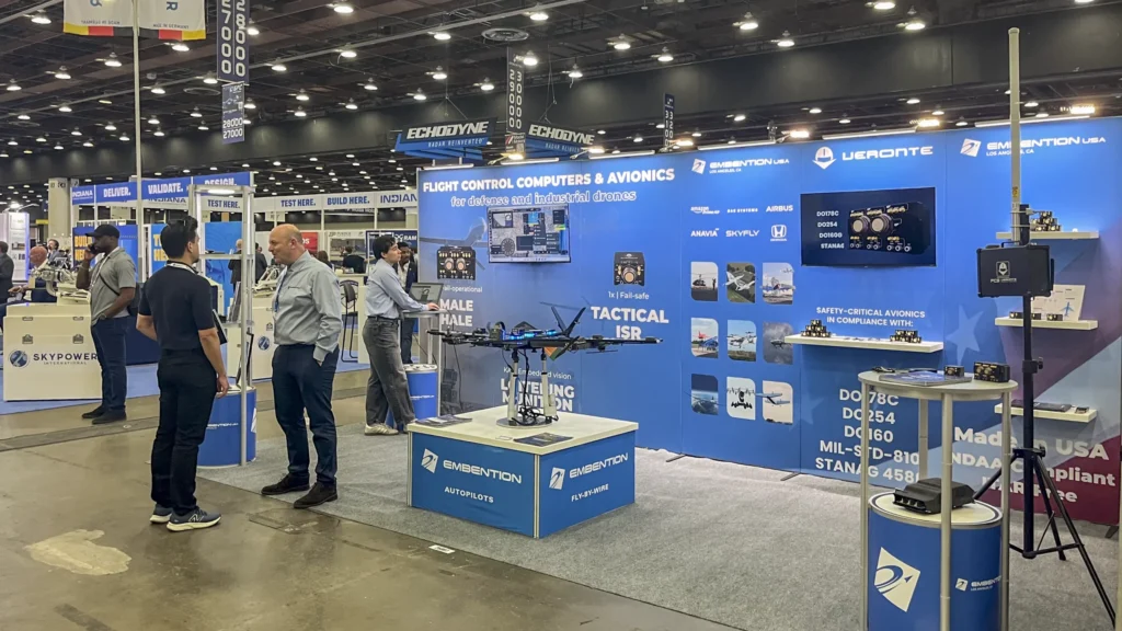
Embention brings its latest autonomous systems innovations to XPONENTIAL Detroit and Loitering Munition USA
Embention participated in XPONENTIAL Detroit and Loitering Munition USA, showcasing its advancements in critical control systems and avionics for drones.
Beyond GNSS: Veronte KAI Redefines One-Way Drone Autonomy
Embention positions the Veronte Autopilot KAI as the definitive leader in next-generation flight control for loitering munitions and counter-UAS operations, delivering unprecedented autonomy, resilience, and mission flexibility to launched effects.
To provide the best experiences, we use technologies such as cookies to store and/or access device information. Consenting to these technologies will allow us to process data such as browsing behavior or unique IDs on this site. Not consenting, or withdrawing consent, may adversely affect certain features and functions.
Functional Always active
To provide the best experiences, we use technologies such as cookies to store and/or access device information. Consenting to these technologies will allow us to process data such as browsing behavior or unique IDs on this site. Not consenting, or withdrawing consent, may adversely affect certain features and functions.
Preferencias
Technical storage or access is necessary for the legitimate purpose of storing preferences not requested by the subscriber or user.
Statistics
Technical storage or access that is used exclusively for statistical purposes.Storage or technical access used exclusively for anonymous statistical purposes. Without a request, voluntary compliance by your Internet service provider, or additional records from a third party, information stored or retrieved solely for this purpose cannot be used to identify you.
Marketing
The storage or technical access is necessary to create user profiles to send advertising, or to track the user on a website or multiple websites for similar marketing purposes.